Describe the building once. CADdillo drafts the floor plan, then draws each exterior elevation from that same plan, with windows, doors, roof, foundation, level marks, dimensions and material notes, as editable CAD linework you can export as DXF or DWG.
Drafting, not a stamped submittal. CADdillo draws the plan. It does not approve, stamp or seal anything, and it does not know your jurisdiction's rules.
Updated . Feet and inches throughout.
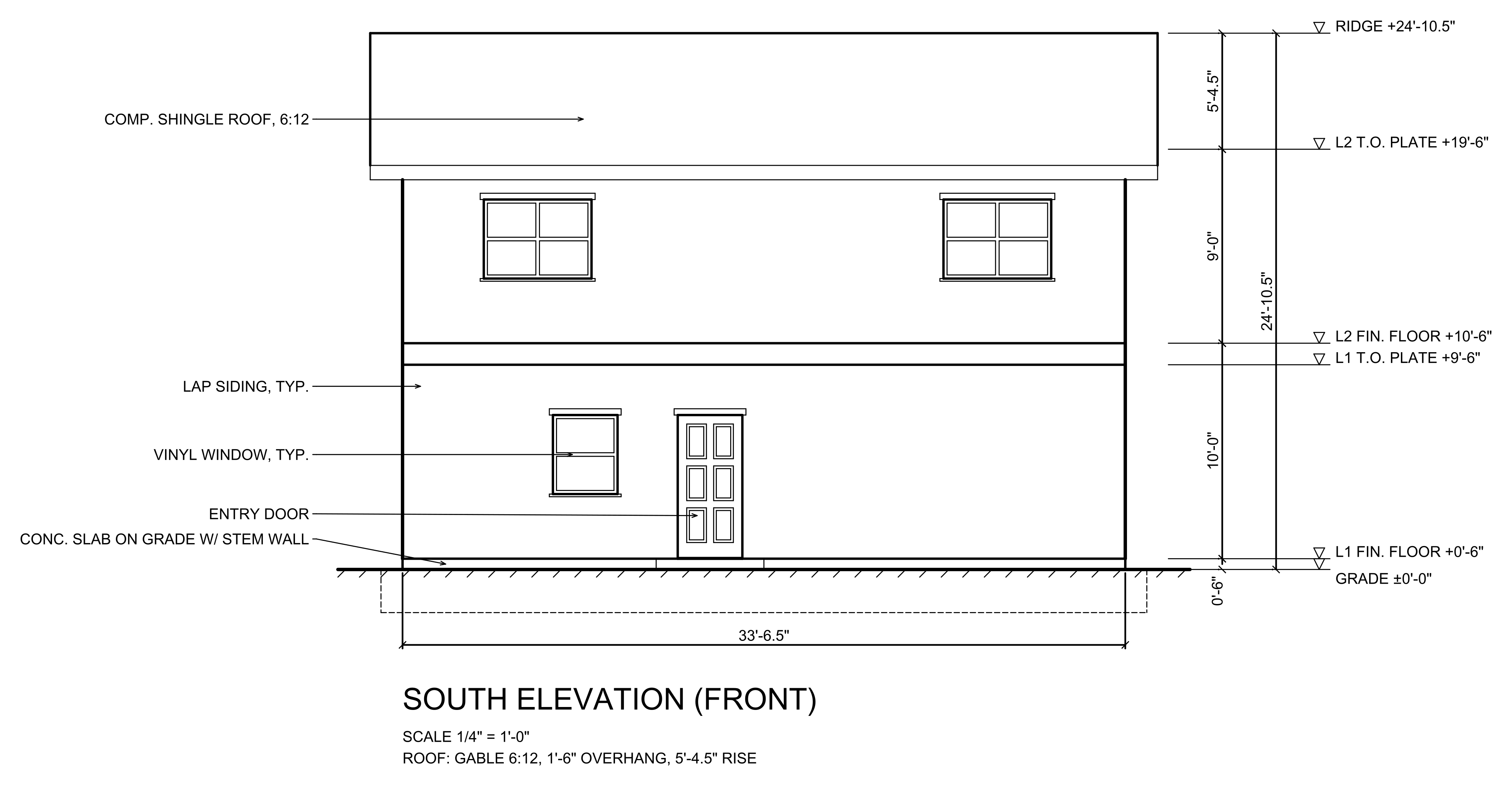
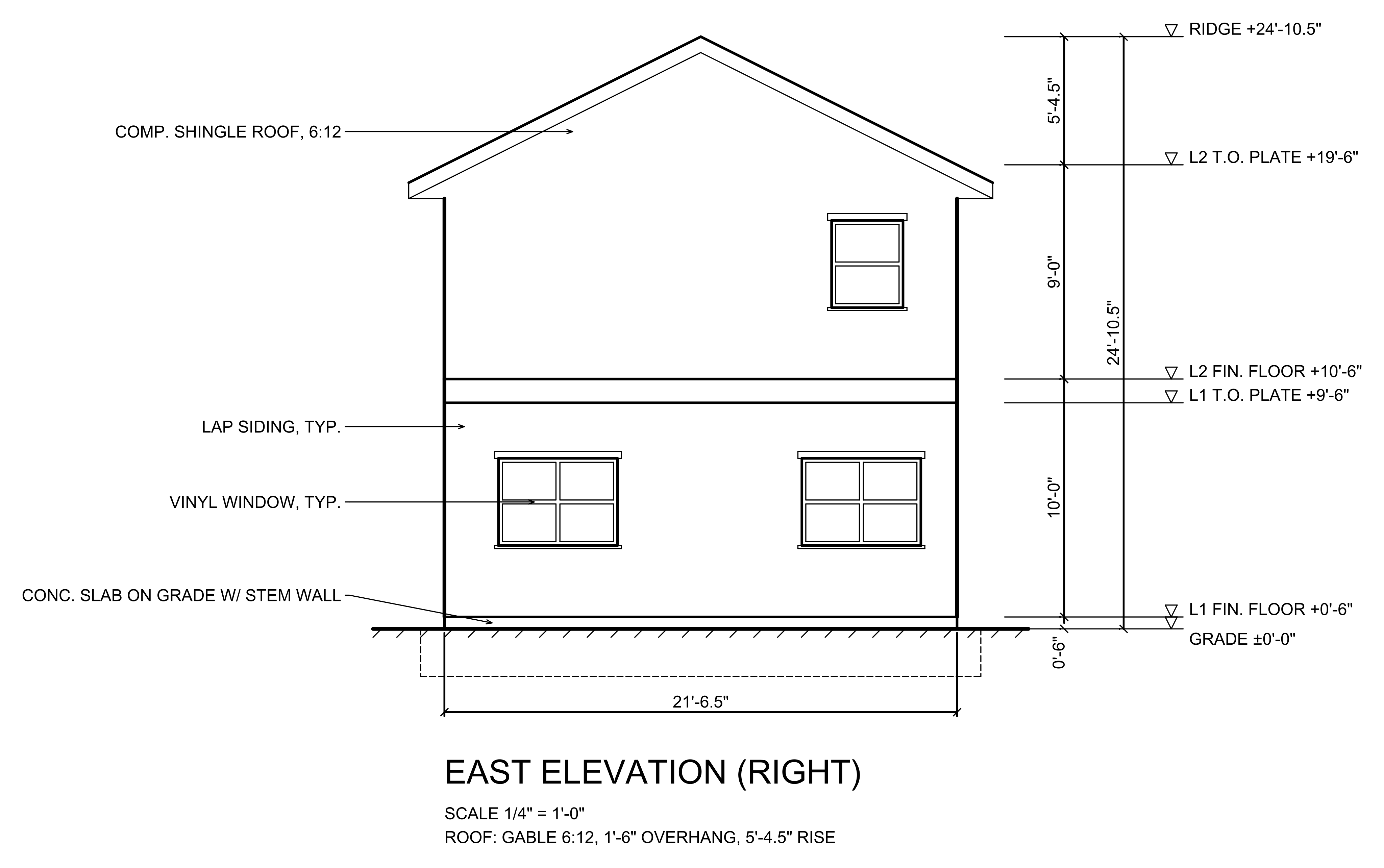
The plan is the top view: walls, doors and rooms as seen from above. The elevation is a side view of the outside: the front elevation is the street face, and the rear and side elevations are the other three. A section is a vertical slice that shows the storeys. Drawing a building as a plan plus elevations is called a multiview drawing. Each view is orthographic, with no perspective, so a height or width you measure is the true one. People searching for a "house elevation" or a "plan and elevation drawing" want this pair.
Type, size or width and depth, storeys, rooms. Then name the views you want, for example "the front and east elevations."
The engine drafts the floor plan first. Check the rooms, doors and windows: every elevation is drawn from exactly that plan, so settle the plan before you draw the views.
Name the sides you want (front and rear, a side, or all four) in the same request. Each elevation lands beside the plan in the same drawing, on its own A-ELEV layers. It is deterministic: the same plan gives the same elevation.
Edit in the browser if you need to, then export DXF or DWG for AutoCAD, or plot the sheet to PDF from the editor.
Free CAD + Free AI: 50 Free AI Credits. No card necessary. Need more credits? Pay-as-you-go. No subscription, no commitment.
Business: custom plans. For architecture firms and design teams: high-volume credits at volume rates, team accounts, API access, priority support. Talk to us
An elevation drawing is a view of the outside of a building seen straight on from one side, with no perspective, so heights and widths measure true to scale. The front elevation shows the street face, with its doors, windows, roof line and ground line. Together with the floor plan (the view from above) it is the standard way to describe a house in an orthographic, or multiview, drawing.
Yes, for a plan CADdillo drafted. Ask Dillo Bot for the plan and then the front, rear or side elevation. The engine builds the elevation from that plan's walls, doors, windows, storey heights and roof, so it matches the floor plan, and it is CAD geometry, not a generated picture of a house. Windows are drawn with sash, sills and head trim at their real heights, the roof with eaves and fascia, and the foundation, grade, level marks, dimensions and material notes are drawn too.
It includes a dimension chain up the side (grade to floor, floor to floor, plate to ridge), the overall height and the overall width, plus level marks for grade, each finished floor, the wall plates and the ridge. Material notes are short leadered callouts chosen from the building type, such as lap siding, vinyl window, composition shingle roof and slab on grade. They are generic words to edit to your own specification, not a finish schedule.
A plan is the building seen from above, cut horizontally about window height, so you see walls, doors and rooms. An elevation is the building seen from the side, so you see its outside face and its height. A section is a vertical slice through the building, so you see the storeys and floor thicknesses. CADdillo can draw a simple building section on request: a cut through the middle of the plan showing the walls and floors it passes through, with level marks. It is not a detailed wall section or a construction detail.
North, south, east and west: four exterior elevations, and one request can ask for several ("front and rear elevations", "all four elevations"). If you say front or street side it draws the south face, and rear or back is the north face, so name the side if your front faces another way. Each is a separate view, drawn beside your plan in the same drawing. It does not draw a roof plan. An interior wall (a fireplace and its chase, cabinets, built-ins) is its own ask: one wall seen straight on, every part dimensioned in feet and inches, with a plan strip for the depths.
Yes. The elevation is real CAD geometry, not an image: lines, text and dimensions on named layers (A-ELEV-OTLN, -WALL, -GLAZ, -ROOF, -TRIM, -GRAD, -LEVL; A-ANNO-TEXT and -DIMS; A-SECT-CUT and -BEYD for a section), each with its own lineweight. Export DXF on any tier, or DWG (R2000); 3 DWG exports are included free. You can also plot the sheet to PDF from the editor. DXF and DWG open in AutoCAD, BricsCAD, DraftSight and LibreCAD.
It works for any building layout the drafter can draw, which includes detached garages and shops, ADUs, tiny houses, greenhouses and a takeaway kiosk, as well as one-, two- and three-storey houses. Every layout in the library produces an elevation, with a gable, hip or flat parapet roof depending on the building. They are drafting elevations drawn from the plan, not shop drawings or product detail drawings.
Not yet. The elevation is built from the plan CADdillo drafted, because that is where the door, window and storey data comes from. A DWG or DXF you upload opens and edits normally, but there is no one-click elevation from an arbitrary plan.
Drafting, not a stamped submittal.